

Sitting in the airport terminal looking out over the vast chaos of a large airport gets people wondering how pilots know what is the right runway to use. Some runways are being used for landing and some for taking off. So how do pilots get the right one?
Runways are identified by large white numbers painted on each end to represent their magnetic heading. Signs, digital & paper airport diagrams, and individual radio frequencies for the navigation systems all help provide additional information to ensure the pilot uses the correct runway.
It is so important that pilots are using the correct runway so how has the global aviation community created ways to help ensure that pilots get it right? Let’s look at the ways pilots identify runways…
How Do Pilots Identifying The Right Runway On The Ground?
When there is only one runway at the airport there can be only two options for the pilot to get it right. They either take off or land in one direction or the other. But how do they know which is the right direction?
Airport Diagrams
Every FAA-certified airport has an Airport Diagram created for it to aid pilots in navigating their way around. This becomes very important at very large, complex airports especially if the pilot/s has never been there before.
On these airport diagrams, all the taxiways and runways are drawn and numbered. These diagrams come in both paper and digital copies and with digital displays and iPads now commonplace in the cockpit the software will use GPS to even show the aircraft’s position on the digital diagram as it taxis around.
This fantastic technological development has really helped pilots from getting lost at large airports and ensuring they taxi to the correct runway for takeoff!
Signage
Airports all over the world have a standard format to the signs used to identify specific airport information. There are signs for runways, taxiways, and frequencies everywhere to help guide the pilots to the information they require.
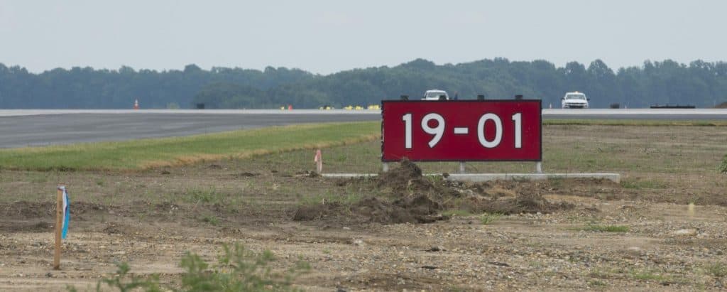
When a taxiway leads to a runway there will be a red & white sign next to the taxiway but just before it meets the runway to show the pilot which runway they are about to turn onto.
This is the last indication the pilot has to ensure they are about to enter the correct runway.
Compass Check
The very last chance a pilot has to ensure they are on the correct runway is when they line up to take off. Each runway is numbered to represent its magnetic heading, therefore if the pilot wants to take off on a runway facing north, they need to make sure their cockpit compass is pointing north.
By now the pilot could be in grave danger if they have taxied onto the wrong runway, but at a quiet airport, especially in low visibility, a quick compass check to confirm they are lined up on the runway they are supposed to be on will ensure no surprises on departure.
Join My Newsletter & Get Great Tips, Information and Experiences To Help You Become a Superb Pilot!
How Do Pilots Identifying The Right Runway From The Air?
You may be surprised by this but runways can be quite difficult to see from the air especially when you are approaching them perpendicular! To help pilots ensure they are about to land on the correct runway there are the following features used in the aviation world
Airport Information and ATC
When a pilot is inbound to an airport for landing one of the first things they will do is obtain the latest weather and airport information for that airport either from a digital communications link or via a dedicated radio frequency for that particular airport.
This pre-recorded information broadcast will tell the pilot what the current runway in use is, or for smaller airports just advises of the wind direction so that the pilot can begin to plan their approach for a particular runway. Then, upon initial radio contact with the airport the pilot will be advised again by the air traffic controller which runway is in use.
For small airports with no air traffic controller pilots will either talk to one another, or if there appears to be no other aircraft around the pilot will make ‘Blind’ radio calls informing any other pilots who might be just listening to their intentions about landing.
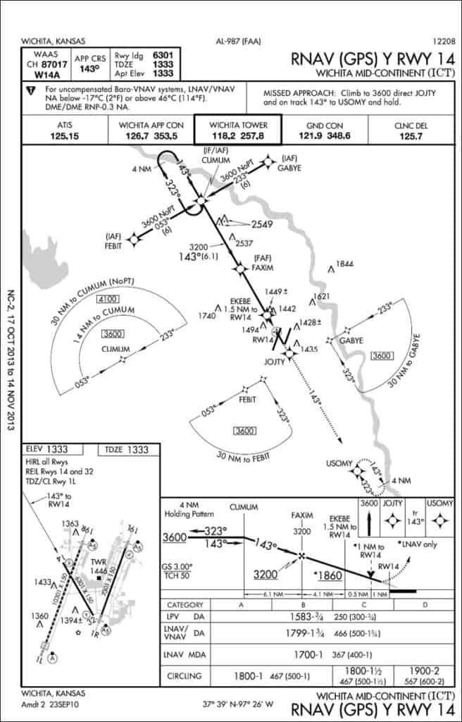
Approach Plate Review
For all airports that have instrument approach procedures, there will be an ‘Approach Plate’ issued by the FAA for that particular approach. This is a diagram and information that the pilots use to identify, navigate to and fly to ensure they land on the correct runway.
This approach plate is for a GPS Instrument Approach to Runway 14 at Wichita, Kansas.
Approach plates show all the applicable information, an aerial view the pilots can use to ensure lateral navigation as well as a side view to depict the vertical path the aircraft should be following.
This approach plate is just another step to ensure the pilot is planning to land on the correct runway. As you can see, the runway for this particular approach is clearly labeled and bolded twice on the plate.
Localizer Frequency
The most accurate type of instrument approach that an airport has is called an ILS or Instrument Landing System. This system uses two radio antennas to send out radio signals along the approach path to the runway.
The Glideslope Antenna creates a 3° funnel down to the runway, while the Localizer Antenna creates a lateral funnel to the runway centerline.
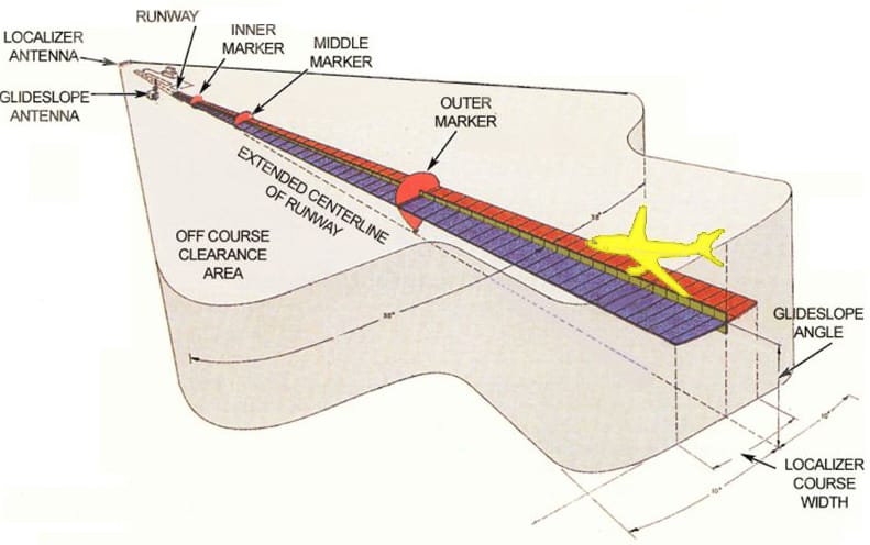
To ensure the pilot is heading toward the correct runway, the Localizer frequency will be different for each runway. The pilots will tune in their navigation radio to the correct localizer frequency and then the cockpit instruments will guide them down the correct funnel for the intended runway.
This correct selection of localizer frequency is very important especially when multiple parallel runways are in use at the airport and the pilots are flying in cloud and are unable to see the runway until the last minute.
Selecting the wrong localizer frequency could cause the pilots to fly an approach to a runway being used for aircraft taking off only!
Cleared for the Approach
Once a pilot has selected the runway on which they intend to land, and selected the approach for that runway, the second to last check to ensure they are going to land on the correct runway is listening to their air traffic controller.
The air traffic controller will clear the pilot for a specific approach to a specific runway. This ensures that the controller has informed the pilot twice of the correct runway to use before beginning the approach procedure.
As you can start to see there is a chain of events that are all designed to ensure the pilot/s have had multiple chances to make sure the aircraft and pilot’s brain are setup for the correct runway!
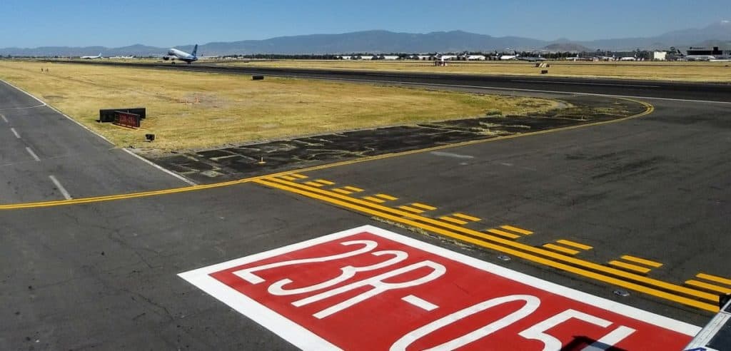
Runway Numbering
As mentioned in the previous section, runways are lined up with the magnetic heading that they face and for each runway it has two directions. Even though it is just one piece of tarmac it is referenced as two separate runways. For easy identification from the air each runway will have two very large, white numbers painted on each end.
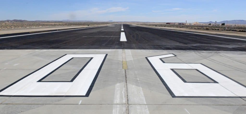
These numbers represent the magnetic direction the rest of the runway faces, so for instance this runway faces easterly and will have a magnetic heading of 060°. Runways are numbers to the nearest 10 degrees and will miss the last zero.
This runway will have 06 painted on the approach end of it. At the far end of the same piece of tarmac, the number 24 will be painted to indicate it is the westbound runway.
When a pilot is on final approach, a quick check of the large numbers against the cockpit compass is their last chance to ensure they are lined up for landing on the correct runway. It begins to get a little more confusing when airports have multiple runways lined up parallel to one another.
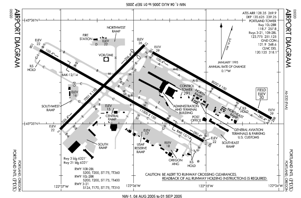
If you look at the airport diagram above you will see that PDX – Portland International, OR has two parallel runways. To ensure the pilots land and depart using the correct runway they are numbered as 28R & 28L and the opposite ends are numbered 10L & 10R.
The letters:
L = Left Hand Runway
C = Center Runway
R = Right Hand Runway
guide the pilot to the runway designated to them by air traffic control. So, for instance, when ATC clears a pilot to land on 26 Left, the pilot must ensure their aircraft is heading 260° and aiming for the left hand runway.
To Finish
Over the many decades that aviation has grown, multiple accidents caused by pilots using the wrong runway have caused incredible fatality numbers. To overcome this the global community has designed many ways to give pilots runway information multiple times before they take off or land to ensure that no aircraft does not go where it is not supposed to.
To be honest, until I sat down and wrote this article I never realized just how many times the runway information was passed to me during a typical flight. It is just second nature, but the system works as I have never been unsure of which runway I’m to land on, it just becomes a little more difficult trying to find small runways in remote areas when you are approaching them from the side.
Large airliners are smoothly guided by air traffic control to be lined up with the current instrument approach in use, then the multiple safety nets used to ensure the correct runway will appear has taken many unfortunate accidents to develop, but now at least, there should be no excuse for a pilot to use the wrong runway.
Further Reading
If you found this article interesting and would like to keep reading, I highly recommend the following articles from my blog:
- Airplane Touch & Go’s – This Is Why Planes or Pilots Do Them
- How Do Pilots See At Night? Everything You Want To Know!
- Planes Landing Sideways – Why Not just Land Straight?
- How Do Pilots Know When To Takeoff?
- Can Pilots Turn On Runway Lights From Their Aircraft?