


For most people flying on an aircraft, the sight of an aircraft punching straight into a cloud is something they will never see. Having done it hundreds of times I can tell you it’s a fun optical moment. However, I have been asked several times how I can see where I’m going when I fly into a cloud.
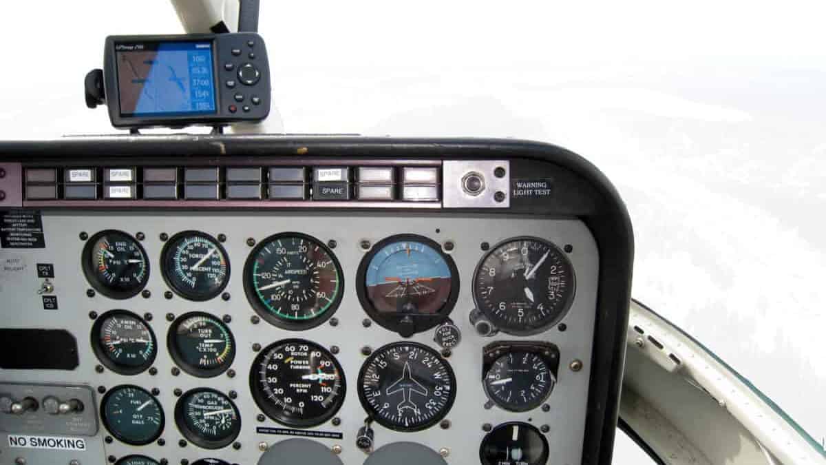
Pilots are unable to see inside a cloud when flying into it. Once the pilot loses visual reference to the earth’s surface they must control the aircraft using sole reference to the aircraft cockpit instrumentation. This is known as instrument flying and is flown under Instrument Flight Rules (IFR).
So to answer the question, as a pilot we can’t see a thing once we have flown into a dense cloud. If the cloud is singular or we climb above or descend below it we can see again, but while inside it there is nothing to see out of the aircraft windows.
To find out how the whole aviation community safely flies within the clouds please read on…
How Do Pilots Fly In Clouds?
There are two different types of flights based on the rules of the air, namely VFR (Visual Flight Rules) and IFR (Instrument Flight Rules).
VFR:
VFR flights are meant to be flown having visual reference with the ground and flying from one ground feature to another as a way of navigating. This is the most common type of flying that is done by flight students, pleasure flights, tour flights, and general aviation.
In the case of clouds obstructing the sky, VFR flights cannot happen once the forward visibility reduces to less than 3nm (nautical miles) if flying in controlled airspace, or 1nm when outside of controlled airspace. It is unsafe and not legal to fly VFR in those conditions because the pilot may be unable to see sufficient detail of the ground to remain in control or see other aircraft around them.
Any pilot flying a VFR flight finding themselves in a condition where they get into a cloud is known as Inadvertent IMC (Instrument Meteorological Conditions). Basically, the pilot now has to fly by sole reference to their aircraft instruments as they cannot see anything outside their window.
If their aircraft does not have sufficient instrumentation and/or the pilot has no experience flying on instruments, statistically the average time it will take for a pilot to become disorientated and begin to lose control of their aircraft is around 20 seconds.
It is not just clouds that can cause this situation but fog, mist, smoke, heavy rain, or darkness. Anytime the pilot is unable to clearly see the horizon or the ground below them they could be in trouble. Pilots are trained to fly under, around the clouds, or if unable, land or not take off in the first place!
Learn More…
Try These Articles:
* Why Do Airplanes Shake & Shudder in Clouds?
* How Do Pilots Understand Air Traffic Control (ATC)?
IFR
Instrument Flight Rules (IFR) is the infrastructure under which most commercial airlines, business & corporate jets, and private IFR-approved pilots fly.
It uses a system of pilot training, aircraft cockpit instrumentation, navigation aids, charts & publications, and runway instrument approach systems to allow pilots to safely takeoff, navigate through the sky, and land all while under the watchful eye of air traffic control (ATC).
Once a pilot takes off from an airport and punches into a cloud under IFR, ATC will begin to guide them. Because pilots cannot see a thing outside of their cockpit windows it becomes the job of air traffic control is to provide separation from other aircraft while the pilot/s or aircraft fly the route they had filed with air traffic control.
That route will have been planned out before the flight, either by the airline’s flight planning department or the pilot if they are on a personal flight or working for a company without a planning department.
To get from origin to destination the route will be planned to be flown along ‘Airways’ using ‘Waypoints’ as markers. Airways are like the highways of the sky and waypoints are usually GPS locations that let the pilot know of a direction change in the airway, a position reporting point, or like an intersection where the planes leave and join the airway.
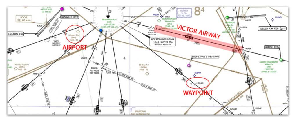
Victor Airways are given a specific alpha-numeric name and it is this name the pilot will place on their flight plan. When flying on an airway the altitude will be based on their magnetic heading. Flights flying easterly heading (000° to 179°) will cruise on odd altitudes – 35,000ft or 37,000ft.
Flights flying westerly headings (180° to 359°) will cruise on even altitudes – 34,000ft or 36,000ft. Each altitude will be refined and advised by air traffic control to maintain traffic separation.
Waypoints in layman’s terms are like a “Landmark”. It is a pseudo point and it doesn’t exist as an object on Earth.” It is merely a GPS coordinate, an area where two radio navigation signal cross or a distance from a navigation beacon.
Join My Newsletter & Get Great Tips, Information and Experiences To Help You Become a Superb Pilot!
In modern-day aviation, the GPS coordinate waypoints are the main waypoints of the IFR infrastructure.
Every waypoint has a unique name consisting of 5 letters with at least 2 vowels eg.: MANGO, EPCOS
It is these waypoints the pilots will also use on their flight plan when planning the route.
A Navaid is a navigational beacon, situated on the ground for the use of air navigation. Every Navaid has its own specific radio frequency and when tuned in to the navigation radio of the aircraft, gets paired with the aircraft, and can be used for homing, holding, en-route navigation, and approaches into runways.
With these technologies, a pilot flying IFR doesn’t need to look out and fly. It doesn’t matter if the visibility is less due to clouds or precipitation. A flight can be planned on specific airways between waypoints or navaids or the combination of both waypoints and navaids. Whatever route takes them from point A to point B.
Think of an IFR routing like this to what you would do in a car:
Kansas City (Waypoint) -> I70 (Airway) -> St Louis -> I55 -> Memphis
The Navigational Display (ND) in the cockpit will show all of these Navaids and Waypoints and lets the pilot know their current position. When the route is fed into the Flight Management Computer of the aircraft, it draws a line on the navigational display (Left Display, Blue Line), which indicates the route the pilot needs to follow during the flight, or the route the autoflight system will take.
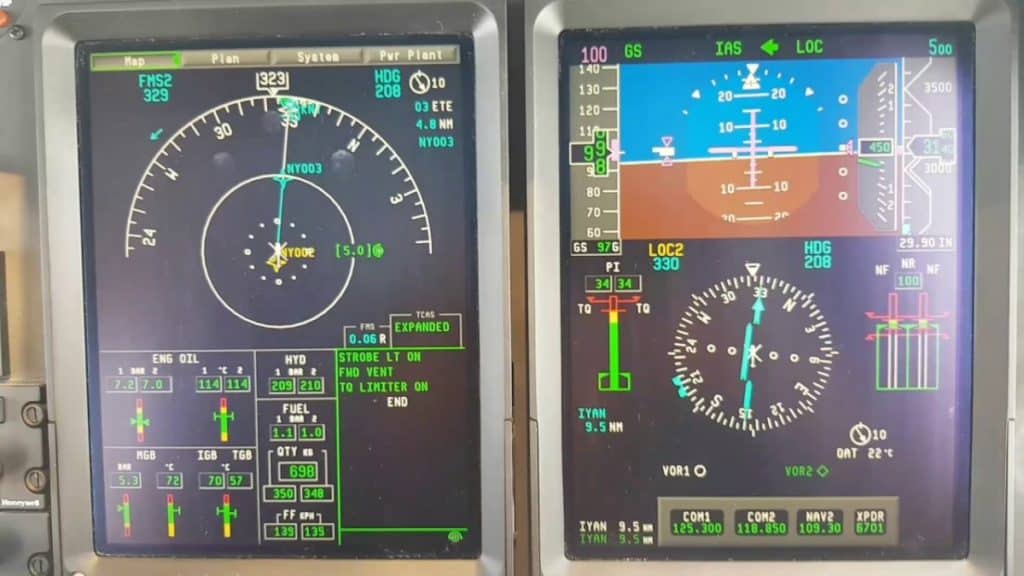
When the pilot flying maintains the aircraft on that line, it makes sure that the aircraft is flying correctly and will reach its destination without the need for the pilot to look out.
For aircraft without this level of digital sophistication, the pilot will need to monitor their progress using a paper chart and radio signals from ground-based navigation beacons to verify their position along the route.
All of these technologies together are what allow pilots to navigate, while ATC is the pilot’s eyes keeping them away from all the other aircraft.
I can tell you from experience that using a modern cockpit with automation makes IFR flying so much easier and fun!
How Do Pilots Land in Clouds?
When clouds or visibility is low pilots use an instrument approach landing system to funnel them down to the end of a runway for landing. Based on either radio navigation beacons or GPS waypoints, pilots can descend and if equipped, land in completely zero or very minimal visibility conditions.
When the pilot is approaching the destination airport, air traffic control will begin giving the pilots descent instructions to get them down from their cruise airway and ready to intercept the instrument approach landing system for their desired runway.
There are various types of approach landing systems, all varying in their complexity and capability. Depending on the type of equipment available in the aircraft and for that runway the pilot will select the most suitable approach landing system and ask for clearance to fly that approach from ATC.
For way more information on Instrument Approach Landing Systems please check out my article below:
Can Airplanes Land In Fog? A Pilot Tells All!
Can Pilots See Thunderstorms?
If flying outside of a cloud pilots are able to visually see thunderstorm cells ahead and correct course to fly around them or ask air traffic control for a course deviation. If flying in clouds and are unable to see the cells they can use a weather radar to display potential thunderstorm activity.
Equipped in most modern aircraft cockpits, the weather radar shows where heavy precipitation is in relation to the aircraft. The radar, which is usually mounted in the nose of the aircraft, scans in a sweeping motion from one side to another in front of the aircraft and detects the precipitation and its severity and it shows in the form of colors on a screen in the cockpit.
Precipitation is a great indicator of a possible thunderstorm cell as heavy rain is almost always associated with a thunderstorm.
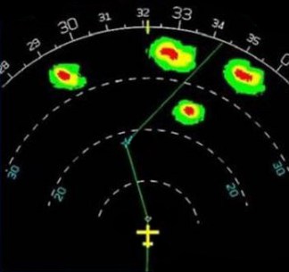
Red areas are the most severe precipitation, yellow is moderately severe, green patches as less severe, and black is no precipitation. This visual data allows the pilots to talk with air traffic control and form a plan of how to try and avoid the heaviest areas of activity while ATC maintains traffic separation.
As you can see on this screen shot the pilot will be changing course to a heading of approximately 020° once reaching their next waypoint to try and fly between the most severe cells.
Learn More…
Try These Articles:
* Why Do Some Airplanes Turn Immediately After Takeoff?
* How Do Pilots See At Night? Everything You Want To Know!