


Last month I was on a smaller commuter airline coming home from a flying tour and the clouds were low, I mean really low as we came into land. I know about landings, weather, pilot, and plane capabilities and I was starting to tense up.
We broke out of the clouds right at minimums (200ft above the ground) and the wheels touched down but I know many people always wonder how the heck pilots know where the runway is when it’s dark outside or they are in clouds!
Pilots use GPS or a radio navigation system called the Instrument Landing System to funnel the aircraft down an approach path to line the aircraft up directly in line with the runway. High-intensity approach lighting systems help the pilots find the runway at night or when breaking out of the cloud.
Not all pilots use the approach systems mentioned because their basic aircraft lack the certified avionics to fly these approaches, so how do they find the runway?
Read on and ill tell you how even helicopter pilots find the runway…
— VFR Flights —
The aviation world is split into two types of flying:
- VFR (Visual Flight Rules)
- IFR (Instrument Flight Rules)
When flying by sole reference to looking out of the aircraft window and seeing the ground, that is VFR.
When flying in the clouds, fog, or at night with no ground or celestial lighting, that is IFR.
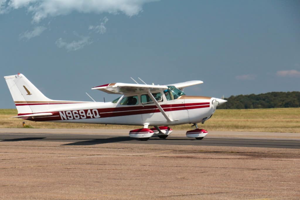
When plodding around the sky in a basic aircraft like a Cessna or Robinson helicopter, the pilots are navigating by looking out the window (Unless they cheat and use a moving map GPS!). The only time they need to look at the instruments in the cockpit is for monitoring aircraft and engine sensor information.
When I am going to a new airport that I have never flown into before and I’m flying VFR, there are several things I do (and most other VFR pilots) to find out information about the intended airport and runway:
Maps
Aviation maps/charts/sectionals all provide a visual location of an airport in proximity to the nearest town. Seeing the airport is on the South East side of the town is where I will be looking as I begin to approach the area.
Google Earth
This incredible game-changer is my next port of call during my flight planning. Being able to look at a satellite photo of the airport and surrounding area helps me look for landmarks or easily recognizable features around that area.
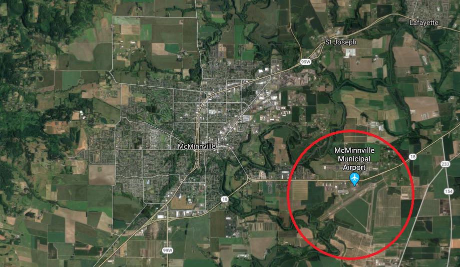
Large transmission towers, rivers, roads, and railway lines all help to pinpoint the airport when entering the area.
This information is really helpful if the cloud is low and you are flying under it and lower to the ground, as the distance you can see dramatically reduces the closer to the ground you fly. Being up high makes it easy to find an airport, but as a well-prepared pilot, you need to be ready for low cloud or reduced visibility.
AFD – Airport Facility Directory
The FAA publishes this directory and it contains all the information about every airport in the country. Runway directions, length, height, surface type, lighting systems, approach aids etc.
By knowing the information about the runway itself I can prepare to line my aircraft up with the direction I wish to land once I have the airport in sight.
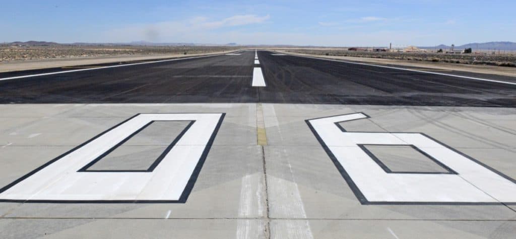
Once I have the runway in sight I then look for big numbers painted on each end which tell the pilot the magnetic heading of the runway and therefore which runway it is.
For Example:
06 = 060° magnetic = Runway 06
Running from the opposite end would be:
24 = 240° magnetic = Runway 24
Pilots always try and land into wind for better aircraft performance so if the wind was blowing from North to South, I would choose to land on runway 06, as that is the one pointing into wind the most.
Join My Newsletter & Get Great Tips, Information and Experiences To Help You Become a Superb Pilot!
Night
At night, VFR pilots need to be able to maintain reference to the surface and this is usually done by the city lights (Unless they are wearing night-vision goggles!). But for most VFR pilots, the MK 1 Eyeball looking at lights is the way to go.
Just like in the daytime, the pilot is looking for the lights of the airport in relation to the city. To aid pilots, most larger airports have a bright flashing beacon at it and completely lit runways, taxiways, and approach lighting systems.
Once the pilot finds the airport, they line up for the approach to the runway with the selected magnetic heading and fly a visual approach down using the runway lighting systems to guide them, then see the runway illuminated by their aircraft landing light/s just before they land.
— IFR Flights —

This is the type of flying that most of you are familiar with. Flying into the clouds and at night under IFR flight rules is how the commercial airline world works.
IFR flight is a system where the pilots fly the aircraft (well the automation does) by sole reference to the aircraft instrumentation as looking out the window will give the pilot zero information. The pilots also get instructions from air traffic control to help guide them around the airspace safely.
GPS Waypoints
When pilots are inputting the route into the aircraft’s FMS – Flight Management System, it will consist of GPS waypoints and routes between those points that the pilots wish to fly. GPS waypoints are a fixed imaginary point over the ground with a Lat and Long Coordinate and a five-letter name.
Think of it like a join-the-dots drawing you did as a child. You join the dots to get from point A to point B. As you begin to reach the end of the dots this is where air traffic control comes in and begins to give the pilots Vectors.
Vectors
Most aircraft are equipped with a device called a ‘Transponder’, it allows the air traffic controller to see that particular aircraft on their radar screen. The controller is then able to instruct the pilot over the radio which way to turn or what altitude to climb/descend to allow them to navigate.
These directional commands given by ATC are known as Vectors
For Example: “United 23 turn left heading 320, descend 5000”
This tells the pilot they need to turn to the left until they are facing 320° and descend until they reach 5000ft then level off.
Vectors are used to get aircraft lined up for landing at all busy airports. When planes are coming in from all directions, the ATC controllers will funnel all the aircraft to one waypoint many miles out from the airport and then have them all lined up for landing using an instrument approach procedure.
ILS – Instrument Landing System
This is by far the most common type of instrument landing system used all over the world. It comprises two radio signals that form a virtual cross hairs from the runway and up into the air.
By keeping the crosshairs centered on the aircraft instrumentation, the aircraft will funnel down the approach and pop out of the cloud with the runway dead ahead.
The ILS consists of two parts:
- The Localizer – Lateral Navigation Guidance
- The Glide Slope – Vertical Navigation Guidance
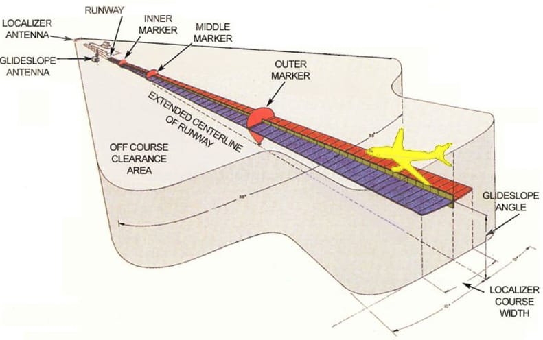
The Localizer
The localizer is a radio signal that comes from an antenna located at the far end of the landing runway. It beams out a horizontal radio signal that spreads out to 70° wide to 10nm, then narrows to 20° for a further 8nm.
This signal allows the pilots (or aircraft automation) to maneuver the aircraft to put the aircraft directly on the centerline of the runway from 18nm back. Drifting left or right of the centerline will be indicated by a shift of the vertical needle on the CDI (Course Deviation Indicator – You will see it in a moment!).
Each localizer has its own radio frequency and by tuning that frequency into the Navigation system, the CDI will begin to show the localizer information once the aircraft comes in range.
The Glideslope
The glideslope is the vertical guidance part of the ILS system. This operates on the same frequency as the localizer but is transmitted from a radio antenna that is roughly 750ft to 1,250 feet past the end of the landing runway threshold and off to the side.
This signal creates a 3° glideslope down to the runway touchdown zone. The signal is much thinner compared to the localizer to keep the aircraft from wandering up and down too much as they get closer to the ground.
On the CDI, the glideslope is represented by a horizontal needle or line.
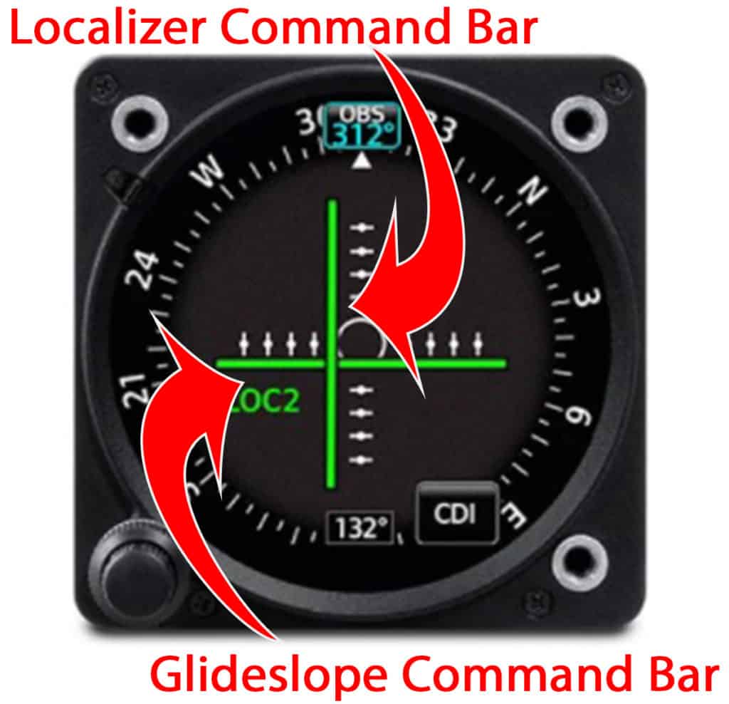
This is a typical stand-alone CDI instrument you find in most basic IFR-equipped aircraft. The bars show the location of the centerlines for both the localizer and glideslope.
In this image, the centerline of the localizer is to the left of the aircraft and the glideslope is below the aircraft.
A CDI incorporated into a glass cockpit Primary Flight Display.
The magenta bars represent the localizer and glideslope centerlines.
In this image, the aircraft is perfectly flying the ILS and at the break out of clouds the runway will be dead ahead.
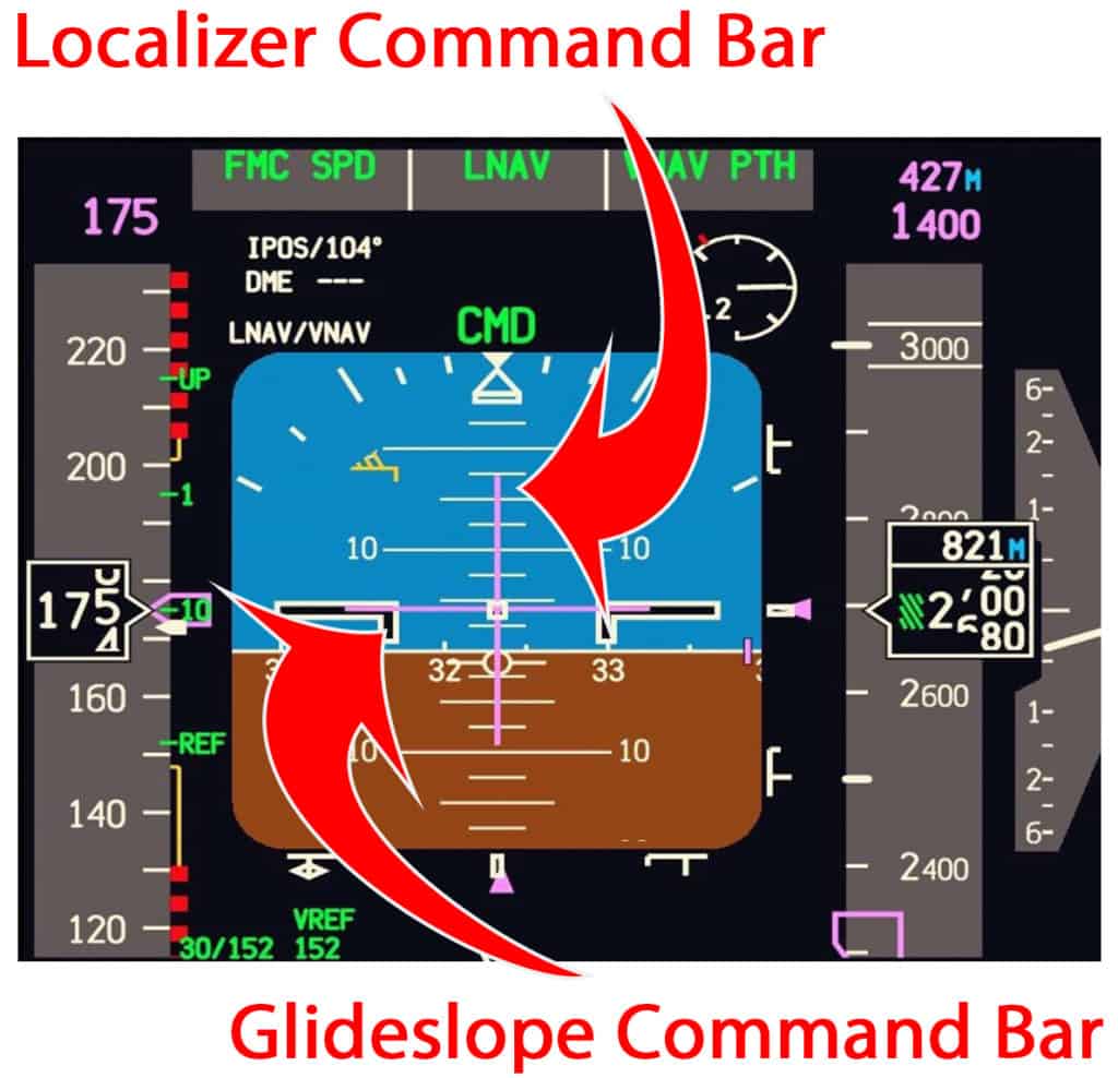
The pilot’s or avionics job is to keep the aircraft as close to the centerlines by flying so the bars are perfectly centered like a cross-hair all the way down until they see the approach lighting system or the runway.
RNAV Approach System
RNAV or Area Navigation is a GPS-based approach and landing system that is getting more and more popular across the world’s airports. An RNAV approach requires no additional radio antenna or equipment to be installed at an airport making it perfect for smaller and private airports/ airstrips to get a certified RNAV approach.
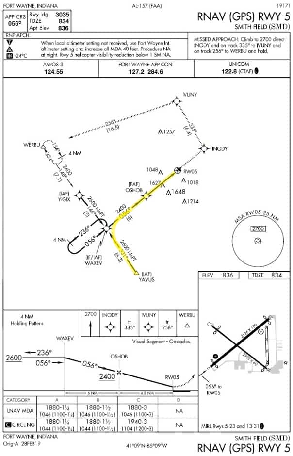
An approach designer will look at the surrounding topography and obstacles and design an approach system using GPS waypoints that create a ‘T’ off the end of the runway.
The pilot will first approach one of the waypoints on the arm of the ‘T’ (YAVUS – See Procedure Image Below) and fly in towards the center waypoint of the ‘T’ (WAXEV). Once turned to now face down the ‘T’ the pilot will fly the approach to the next waypoint (OSHOB) while descending to the minimum allowed altitude for each sector:
- YAVUS to WAXEV = 2600ft
- WAXEV to OSHOB = 2400ft
- OSHOB to Runway 05 = 1880ft
If the pilot sees the runway from this height they can continue to land. If they get to this height and fly all the way to the RWY05 waypoint and have not seen the runway or approach lighting system, they must begin to climb back up and initiate the Missed Approach Procedure.
The pilot/s now have to choose to try the approach again and hope the weather has improved or fly to an alternate airport that has better weather.
The moving map displayed on a screen in the cockpit will show the aircraft’s position in relation to the waypoints. This is how the pilots are able to monitor the aircraft and ensure they are flying to the correct point.
To Finish
Pilots are able to find the runways by either using their own eyes or by guidance from either an air traffic controller or some form of instrument approach aid like the ILS or RNAV systems.
There are other types of approach aids like the VOR and NDB radio navigation systems but they are being phased out all over the world. Currently, the ILS is the most accurate and allows pilots to fly down to 200ft above the runway, or in modern commercial airliners they can autoland in completely zero visibility!
The GPS accuracy is not there yet and descents down to 4-500ft above the runway are common but they are much simpler to get designed and implemented for the smaller airports.
So when you are next looking out of the plane window and you have heard the wheels are down but you still cannot see the ground, don’t worry because the plane and pilots are on the ball!
Further Reading
If you found this article interesting and would like to keep reading, I highly recommend the following articles from my blog:
- Captain or Co-Pilot: What is the Difference?
- What Fuel Do Aircraft Use? – Same As Your Car???
- Ever Wonder How Pilots Know Where To Go? This Is How!
- Why Do Some Aircraft Fly With Two Pilots, Not One?
- Can Pilots Turn On Runway Lights From Their Aircraft?