

Have you ever been stuck in the departure terminal because the flight has been canceled due to weather or the plane you have been flying on has had to divert to another airport because of weather? If so, then this article may be of interest to you.
Pilots access whether via websites, radio & telephone briefing services, radio broadcasts, pilot reports, satellite and weather radar imagery, and their own eyesight. Knowing the actual and forecast weather conditions allows pilots & air traffic controllers to make decisions regarding flight safety.
Cloud heights, forward visibility, thunderstorms, and severe weather phenomenon dictate how flights operate all over the world on a daily basis. Before a flight takes off, flies a route, or lands the pilots must know the weather to be able to make alternative arrangements, postpone or cancel the flight altogether.
Ways of Getting Aviation Weather Information
Over the past few decades, the methods that have become available for pilots and air traffic controllers to access the latest weather information and forecasts have really improved. Getting accurate weather at all points of a flight process allows for timely decisions to keep everyone safe.
Some of the best methods available for pilots to access weather reports purposely tailored to aviation are:
Aviation Weather Websites
The most used website is the Aviation Weather Centre from NOAA (Link).
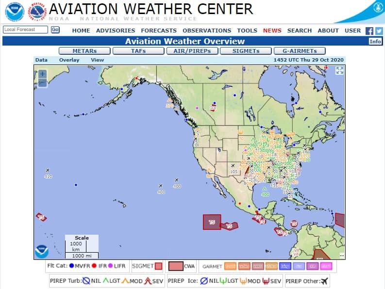
This website uses all the weather data gathered by NOAA and puts it into dozens of formats covering all the US and at all altitudes. It is used by all kinds of pilots whether they are flying a hang glider or a Boeing 747!
The great feature of aviation weather websites is that it allows pilots to check local weather around an airport, which is great for takeoff and landing weather information, then with a click of a mouse can view the weather over the whole of the US to check the routing of the flight.
Many parts of the website have text-based and/or graphical images to show all the relevant information and as pilots go through their pilot training they are taught how to read, decode and interpret all the weather information that will be pertinent to them
Some other notable websites that are popular are:
Join My Newsletter & Get Great Tips, Information and Experiences To Help You Become a Superb Pilot!
Telephone Weather Briefing Services
When the internet is not available to pilots but there is cell phone or landline coverage pilots are able to access several telephone services run and maintained by the FAA.
The two main telephone services available are:
- Telephone Information Briefing Service (TIBS)
- In-person Briefing Service
The TIBS service is available for pilots who just wish to hear a recorded message of the current weather for a particular airport. This is especially useful for a quick weather check. TIBS can be accessed by calling 1-800-WXBRIEF or one of the local numbers listed in the FAA Chart Supplement Publications.
In-person briefings give the pilot access to a specialized aviation weather briefer who can give the pilot weather information for specific areas or routes of flight anywhere in the country. The personalized conversation allows the pilot to get the exact weather information they require.
These are by far the most used telephone services used. I use them all the time when the weather in the remote parts I operate is looking iffy for the day. Getting a second opinion from a specialist really helps solidify my weather decision.
The in-person briefing service can be accessed by the same 1-800-WXBRIEF telephone number.
Weather Radar
Most large jets, corporate jets, and IFR-equipped helicopters all come with onboard weather radar. This device sits in the nose section of the aircraft and sweeps side to side looking for precipitation in the upcoming airspace.
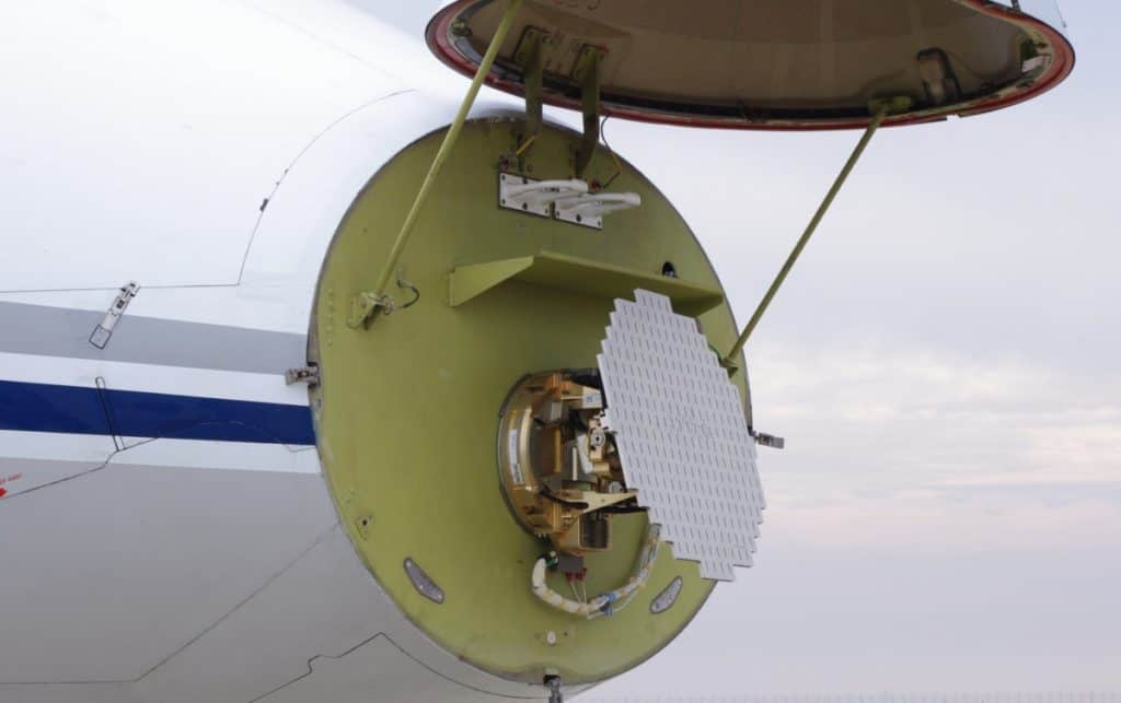
When the radio signal sent out from the radar reflects back off precipitation it gets shown on a screen in the cockpit. The larger the precipitation drops and the more the amount of them, will show up as patches of varying color that identify the intensity of the weather ahead.
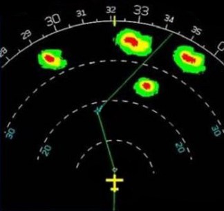
This allows the pilots to alter the course of the aircraft to fly around the most intense storm cells. The intense rain is often conducive to turbulence associated with Thunderstorms.
XM Satellite
For pilots of smaller aircraft that do not have the luxury or bank balance to have a weather radar installed, they can use a really handy function with a Sirus XM membership.
Sirius offers an aviation weather service that can be used on a standalone device or linked to an iPad running navigation software like Foreflight or Garmin Pilot. For use with the iPads, a small antenna can be purchased, and linked to the iPad then the pilot will receive textual and graphical weather data right on their iPad screen.
If you are a pilot and are interested in finding out more about Foreflight and the Sirius XM weather interface you can go Here to the Sirius XM website.
Air Traffic Control & ATIS/AWOS
Most airports throughout North America have two ways to get the latest weather information to a pilot while in flight:
- An Automated Weather Information System
- An Air Traffic Controller
The Automated systems come in a range of types, with each one offering different levels of weather reporting detail.
ATIS – Automatic Terminal Information Service is the one used by larger, busier airports. It will consist of its own frequency that pilots can tune to and listen to the latest weather.
The ATIS is either a recorded report from an air traffic controller recorded every hour or it can be from an automated system that uses a digital voice to communicate the weather information.
AWOS – Automatic Weather Observing System is a fully automated series of sensors that read slightly fewer weather parameters and communicates them verbally on a designated AWOS frequency for that airport.
AWOS facilities are usually found at smaller, non-manned airports.
The typical information a pilot can receive from the ATIS/AWOS weather broadcasts usually consists of:
| Altimeter Setting | Bravo |
| Airfield The ATIS/AWOS Broadcast Is For | Fairbanks |
| Time (UTC) Observation Taken At | 14:20Z |
| Runway In Use | 20R (200º) – Righthand Runway |
| Wind Speed & Direction | 255º @ 5 kts |
| Visibility | 6 Nautical Miles or more (maximum) |
| Cloud Cover | Few @ 3000 feet and broken @ 5500 feet |
| Temperature | 15 °C |
| Dew point | 8 °C |
| Altimeter Setting | 29.92 inHg |
The other great feature about the ATIS/AWOS is that it gets automatically transcribed into text and this is the weather report that gets used by all the websites across the world that ask for the latest weather in that town.
For a sample of what an ATIS broadcast sounds like Click Here to listen to a report from London Stanstead Airport.
Pilot Reports – PIREPS
Even though digital sensors and trained weather forecasters do a great job of reporting the weather nothing can beat a pilot flying in the actual weather at that time.
A pilot can call back to an air traffic controller to give them details of the actual weather they have encountered so the weather reports can be updated to give a more accurate report.
One of the most common PIREPS that I personally report when flying out of an airport is the lowest cloud ceiling. This is especially important for VFR pilots who have to fly under the clouds.
An accurate cloud height could mean the other pilots are able to get in or out. It also helps if the weather around the airport is not consistent. Low clouds out to the west but clear out to the east. Sensors and observations are only taken directly over the airport.
Eyesight
Just like the PIREP, the pilot’s eyesight can give them lots of information about the weather around them. Storm cells, rain showers, snow squalls, and cloud banks are all easily seen from the cockpit.

When the sky ahead of the pilot is black and there is no other way of finding out the weather it might be time for the pilot to turn around if the sky looks too menacing. This is typical for a VFR pilot flying around in a small aircraft.
The pilots flying the larger airliners will have had their routing changed by their company dispatch office before the flight to ensure the plane flies around most of the forecast junk and ensure a smooth ride for its customers. For those times when turbulence is encountered, it may not be seen or forecasted, hence the reason why you should always fly with your seat belt on.
To Finish
Because pilots are flying in the area where weather occurs they need to have an understanding of what the weather is going to be like for them. Some weather can be uncomfortable to fly in, some can break aircraft and some can stop the pilot from seeing the ground altogether.
With modern technology, pilots can fly into weather that is far worse than a pilot out in his Cessna. As a pilot, knowing your own personal limits of what you and that aircraft are capable of flying in is key and the only way to do that is by getting as much, detailed, and timely weather information as you can.
Further Reading
If you found this article interesting and would like to keep reading, I highly recommend the following articles from my blog:
- How Does Wind Effect a Helicopter? Pilot Tells All!
- Flying Above Clouds: Can Helicopters Do That?
- How Do Pilots See At Night? Everything You Want To Know!
- Can Helicopters Fly In Snow & Ice? This May Surprise You!
- Ear Popping: What Techniques Do Pilots Use To Cope?